
The Goat Trails of Palm Springs
Sitting at the eastern base of the San Jacinto Mountains, the Goat Trails of Palm Springs offer a plethora of singletrack that varies from swooping flowing gradual downhill to gnarly exposed, steep and loose technical goodness It is pretty much a pick your poison kind of place, as long as your poison includes lots of cacti, rocks and some pretty awesome views from narrow single track. According to which way you go you can log somewhere between 7 and 14 plus miles. I find the miles are out here to be "long" miles as you certainly feel like you further than you actually did. Either way your lungs will get a workout while here. The Goat Trails are also part of the Classic Palm Canyon Epic route.
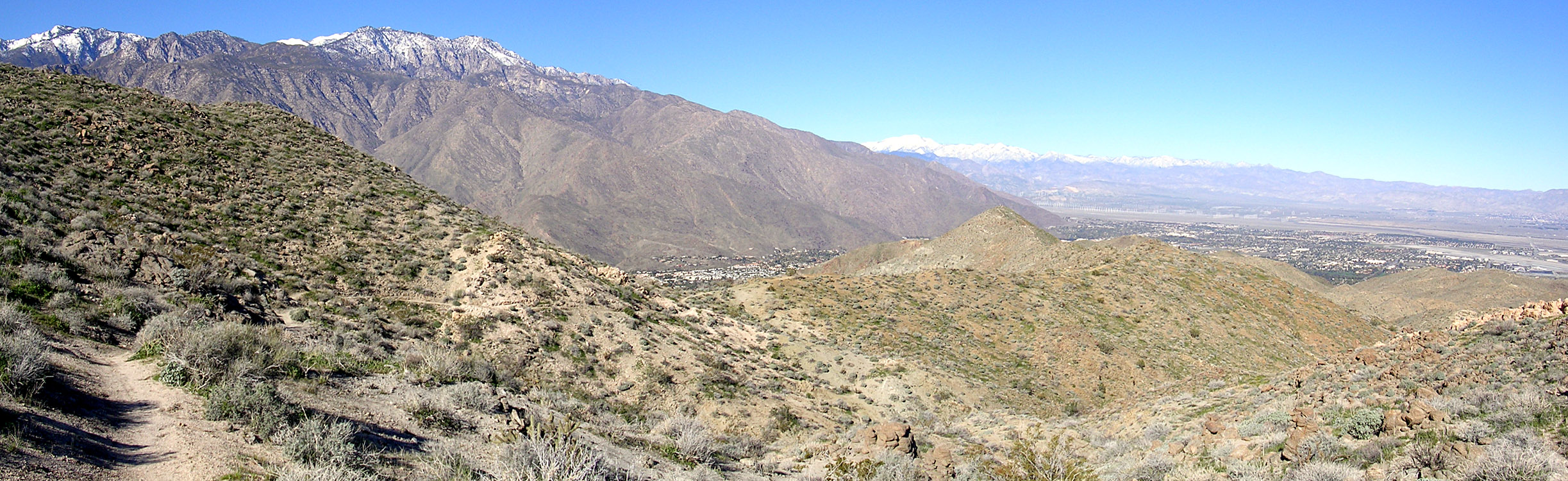 Pan shot from the Clara Burgess trail looking NW at the Wild Horse running
along the ridge top in the distance.
Pan shot from the Clara Burgess trail looking NW at the Wild Horse running
along the ridge top in the distance. Hazards: Narrow trails along with cactus some exposure. It can get pretty freaking hot out here in the summer. The good news town is never really that far away.
Goat trails with Wildhorse :
A quick grind
Goats Over Murray Hill
<


Directions:
- The Trailhead is located just east of the Rimrock Shopping Center (Vons) at 4733 East Palm Canyon Drive which at the intersection with the
Gene Autry Trail.

Ride Description

 From
the Shopping Center head out of the east side of the parking lot and turn right
heading up to a locked gate and dirt road heading uphill beyond it. At .70
Miles after climbing up past the water tower the dirt road levels off a bit it
and turns south (right) and uphill. It is rather steep and a rocky rutted
out fireroad but it is clearly rideable. Once past this section the fireroad
starts leveling out and around 1.3 miles there is a fireroad going off to your
left. Continue straight for no more than a hundred yards where your views will
open up.
From
the Shopping Center head out of the east side of the parking lot and turn right
heading up to a locked gate and dirt road heading uphill beyond it. At .70
Miles after climbing up past the water tower the dirt road levels off a bit it
and turns south (right) and uphill. It is rather steep and a rocky rutted
out fireroad but it is clearly rideable. Once past this section the fireroad
starts leveling out and around 1.3 miles there is a fireroad going off to your
left. Continue straight for no more than a hundred yards where your views will
open up.
This is a good spot to set your visual bearing with the map. You should be near Waypoint 33. Off to your left you should see a large peak. Turn and face this peak. This is Murray Hill. The Clara Burgess Trail goes up to this peak and over the other side and along follows the ridge tops from the peak towards your right. Clara Burgess will meets up with the Wild Horse Trail at a saddle which should be at your 1 o'clock (Waypoint 22). Wild Horse follows ridges tops further around your right to what should be very distinguishable peak at the end of a ridgeline at little past your 2 o'clock. (It might be just obscured according to you height and where you are standing). The trail continues further to your right down that peak to the far upper end of Eagle Canyon (Waypoint 23). Eagle Canyon goes from this position downhill from your right to your left. Their is a crossing to the other side of the canyon is direct in line from your current position and the peak. You should be able to visually divide up this are at this point to help keep your bearings.
While there no right way to ride this system, I would suggest start out by staying on the west side of Eagle Canyon and work you way uphill and south along any of the fireroads or single tracks you come across. Once you gain some elevation then hook up with the downhill trails. You repeat this cycle over and over all day long and probably not ride the same trail twice.
Some the Views and Trails of the Area


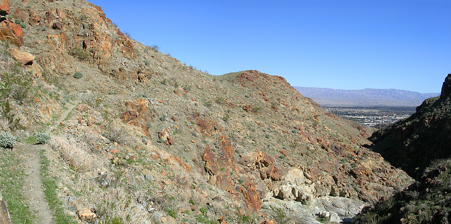
There are some really cool bits of single track that work along and into Eagle Canyon. There are some signs on for a McManus trail but I could not never figure out what trail it actually was. It was all good stuff. There is s very prominent trail that crosses Eagle Canyon wash and head up toward Waypoint 20. This is your primary access to check out the trails to the east of Eagle Canyon.
Trails along Eagle Canyon and the McManus trail areas.

Looking down Eagle Canyon

Canyon side trail

Another shot of the canyon side trail

This trail working it way out of Eagle Canyon

At Waypoint 19 - Junction McManus and Eagle Canyon trails

At Waypoint 19 - Junction McManus and Eagle Canyon trails

Skinny Singletrack

Singletrack heading down into the canyon

More goodness heading into the Canyon
Pan shot from down in Eagle Canyon
There are no shortage of trails east of Eagle Canyon. I saw many trails but on this trip I was interested in the Clara Burgess trail.
The Clara Burgess Trail
The Clara Burgess Trail takes you up and over Murray Hill, the largest hill in the immediate Palm Springs area. I am not sure wither or not this trail is considered part of the Goat Trails or not, but I ended up on it none the less. This is one tough climb. There are some tight switchbacks and the grade can get pretty freaking steep in stops. Climbing this trail from the North (Waypoint 20 on my map) is the steeper approach. Coming up from the South-Southeast (Waypoint 22) is much easier going. From either direction most people will find themselves hike-a-biking the final set of switchbacks to the summit.; When I did this trail I went up from the north from Waypoint 20 on my map and it was a quite a bruiser. It was well worth effort as I was rewarded with seemingly endless views and an awesome descent on the other side down to the Wild Horse trail.

Looking Northeast at the lower end of the Clara Burgess Trail which is waypoint 20 on the map.

The bottom of the Clara Burgess trail (Waypoint 20)

From the summit and looking at the trail running south along the ridgeline

It gets a little steep in spots

Try not to blow this switchback

Sometimes the views themselves are a hazard as they can make it hard to keep your eyes on the trail.


 From Murray Hill, at the top of the Clara Burgess Trail looking east down to Dunn Road at the turn off to head over to the Goat Trails area as part of the the
Palm Canyon Epic. On my map it is the black dashed splitting off of Dunn
Road.
From Murray Hill, at the top of the Clara Burgess Trail looking east down to Dunn Road at the turn off to head over to the Goat Trails area as part of the the
Palm Canyon Epic. On my map it is the black dashed splitting off of Dunn
Road.

A 360 degree pan shot from the top of Murray Hill on the Clara Burgess Trail
The views from the summit are mighty impressive. From the Pan shot above, you can see Dunn Road on the far right and Clara Burgess running along the ridgeline about 1/3rd of the way from the left. In the distance you can see the snow capped San Jacinto Mountains. Just to the right of the rocky peak you can see Palm Springs and the Airport below. Further to the right you can see Cathedral City and Palm Desert.
Wild Horse Trail
While Wild Horse is another trail that I am not sure if it is considered part of the Goat Trails or not but it is assessable from the Goat Trails. I connected to the Wild Horse trails from the Clara Burgess trail at Waypoint 22. This is great trail bit of single track with stunning views on both sides as you ride along the spine of a ridge. This ridge ride is over far to quick, but the grin on your face should last at little longer.

The lower trailhead (Waypoint 23) is the junction with the Garstin Trail as well as connectors to many more trails in the area.

I am not sure if the Wildhorse trail ends here or wither it turns north and downhill to Waypoint 24. Either way it is a fun route.

The views from the little peak on the trail southeast looking back up the trail.

Just past the peak were it gets a little steeper with a few tight switchbacks.

No matter which route you take, don't be too concerned about staying on the dirt all the way back to where you parked. When it is time to head back to your car, simply head north and downhill. You might not come out where you started, but as longs as you head downhill you will end up on pavement and eventually CA-111/East Palm Canyon Drive. From there you can connect back to the Rimrock Shopping Center by the streets. You might not want to drive too far to ride just this area, but if you are in the area you should really check it out.
Here are some views from the Goat trails on February 5th 2005 to do some more exploring. The wild flowers were starting to bloom and it was absolutely beautiful. Here are some picture from that ride


