Mountain Bike Bill, The Dirt on the Dirt

Boden Canyon Update

Here is some news you can use concerning the Boden Canyon portion of the Orosco – Boden Loop.   It turns out the California Department of Fish an Wildlife (CDFW) owns a couple of parcels of land in the canyon and have it designated as an ecological preserve.  The agency’s default policy is that mountain biking is not allowed on ecological reserves.   I was made aware of this by CDFW after publishing the route.   I made them aware of the lack of signage concerning trail use restrictions.   It is my understanding that the signage has probably already been corrected.    I have updated my page, map and GPS files to reflect the CDFW parcels.  Unfortunately, the CDFW trail use restrictions makes it impossible to legally loop together the Lower Santa Ysabel Truck Trail and Orosco Ridge.

BodenOrosco-29APR15-18

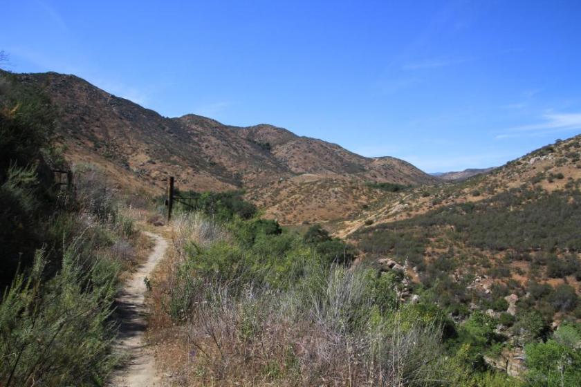
As you can tell from the pictures, the canyon is beautiful and is well worth a hike through.    The only other way you can go legally enjoy this canyon is during hunting season.  During the upland bird hunting seasons you are more than welcome to trounce around wherever you like in the ecological reserve and blast the heads off those birds with a shotgun.    I’m having a tough time trying to make sense of how the CDFW can view killing birds as a more acceptable use for this land than allowing mountain bikers and equestrians to pass through the canyon on the old road.   I’m going to leave my commentary at that for now.    If I get some reasonable justifications for the policy in the future, I’ll provide an update.  Until then beware that you can’t legally do the Orosco-Boden Loop on a mountainbike or horse.

User Registration Fixed

mail

During one of my previous BLOG software updates I misconfigured the email settings which prevented users from receiving the systems emails when they either tried to register or when they requested password resets for retrievals.   I fixed this last night so that function now works.  I apologize for the inconvenience.   Also please note that I in the coming weeks I will be sending out a system wide email for actual human and current user validation.   I have had a glut of spammer attempts over the last couple of years and I suspect there is a fair amount of scrubbing to do with the registered user database.

UPDATE:  The user database has been scrubbed and some new anti-spam goodies are in place with some fairly aggressive parameters.   I’m fairly certain a few legit users were caught in the “nets”.   I apologize if you were affected, but you will have to re-register.

Thanks,

Bill

Orosco Ridge – Boden Canyon Loop

I have added a page to the site for the Orosco Ridge and Boden Canyon Loop near Ramona.  This is 14.2 mile loop that includes about 2,200 feet of total climbing.

OroscoBoden-22APR15-04

An old road/truck trail turned singletrack through a meadow in Boden Canyon.

BodenOrosco-29APR15-02

Mother Nature is doing good stuff to the Lower Santa Ysabel Truck Trail.

BodenOrosco-29APR15-18

This old road in Boden Canyon has turned into some singletrack goodness.    Check it out!

Mule Hill – San Pasqual Valley

I added the Mule Hill and San Pasqual Valley trails located near Escondido to the site.  You may also hear these trails referred to as Raptor Ridge as that is the top of the climb.   While this is for the most part a non-technical trail, the farmland scenery not typically associated with San Diego it offers is worth a look-see.

LakeHodges-RaptorRidge-10JAN15-04

Black Mountain Page Updated

I have finally finished a long overdue update of my Black Mountain in Rancho Bernardo trail guide.

It can take quite a bit of work to get to all of the trails in this area so it took several visits.  I had forgotten just how easy to rack up a bunch of the elevation gain out at this place.

There has been some nice working going out here. The new Lilac trail is a great addition to the place and Miners Ridge Loop is in great shape.  The revised guide includes routes that use the Nighthawk connector which adds some additional options for getting up to the peak of the mountain.  So if you have not been to it in a while it is well worth it give the place another look if you call the San Diego area home.

CRHT Page Added

I have added a page to the site for the California Riding and Hiking Trail.  At this point its designed to share my on-going information gathering on the trail in the form of an interactive Google map.   I have not physically ridden all of the sections of the trail so if during the course of looking at my information you have some information to share feel free to comment here or email me.

IMG_4228

GPS files being updated

I am in the process of going through some of my older pages that only have National Geographic TOPO! map files.   I’m adding GPX, as well as Garmin Mapsource as well as Google Earth KML files. I’m also adding link/icon to the pages to search the blog and provide a list of related posts.   Currently the Hollenbeck Canyon, Noble Canyon and Tour De Noble pages have been updated with others to follow.

New Review Up! Crestridge

I have finally gotten off my butt and finished up new trail review on the website proper.   The Crestridge Ecological Reserve.   In the last year I have mostly been doing blog posts or updating existing pages.  I have at least a dozen other trail pages in the works so hopefully it won’t take as long to get the next one out.   Then again beer, bikes and life in general could foil that plan.

Lunchtime at La Costa

I squeaked in a lunch time ride today out at La Costa with Michael Paul aka YetiRider. Homee has been a program and been slimming up.  Down 15lbs already.  (I think he is trying to get down to women chasing shape)

image

Michael is certainly climbing quicker. Good on ya!

image

It was a mighty pretty day out today as well.    All the better to be out riding a bike.    On a final note, this is my first shot at using the mobile app for making posts do I’m going to have to see if this is going to meet my needs or not.