
Holy Jim - Trabuco Canyon Loop
The Trabuco Canyon, West Horse Thief and the Holy Jim Trails all share a common trailhead which makes them easy to combine into some really nice riding. I already have a web page for both Holy Jim and Trabuco Canyon. This page describes the loop and shows some pictures of the Main Divide Truck Trail that connects to two up.
Holy Jim Trail Trabuco Canyon
Directions: (From San Diego) Take the I-5 north. After passing through San Juan Capistrano and just as you near the Mission Viejo area, take the Oso Parkway exit. Turn right and take Oso Parkway east for 2.5 miles. Turn left on Antonio Parkway and take it north for 5.6 miles. Turn right on Santa Margarita Parkway and 2/10ths of a mile later turn left on Plano Trabuco Road. After .6 miles the road will turn to the left and become Trabuco Canyon Road. After traveling .8 miles and you will see a dirt road on your right just before a small bridge. Turn right onto the dirt road and take it 5.5 miles to its end.
Park there at the end and the trail starts from there. The dirt road can be pretty rough, so ride with someone who has a truck. Some people park right at the beginning of the dirt road and ride their bikes in to the trailhead.![]()
Wild Fire Impact:This area has seen two wildfires since 2018. The USFS has closed the road leading to the trailhead that services Holy Jim, Trabuco and West Horsethief. Additonally, Main Divide Truck Trail is closed from Santiago Peak to the junction with the Indian Truck trail which impacts access the Cold Water Canyon Trail as well. The closure is currently ordered until at least May of 2023. Many believe that he USFS is slow rolling the reopening of these trails. Here are the Alerts and Notices section of the USFS website.
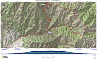

Maps and Resources: The PDF map to the left is formatted to be printed on legal (8.5" by 14") sized paper. While the route description below starts from the trailhead the map includes the dirt access road since some people will low clearance vehicles may want to start from there.
NOTE: This is also an excellent route done in reverse, going up Holy Jim and down Trabuco. The climb up Holy Jim is easier than going up Trabuco. I have done the route both ways and I would give a slight edge to the reverse of this described route.
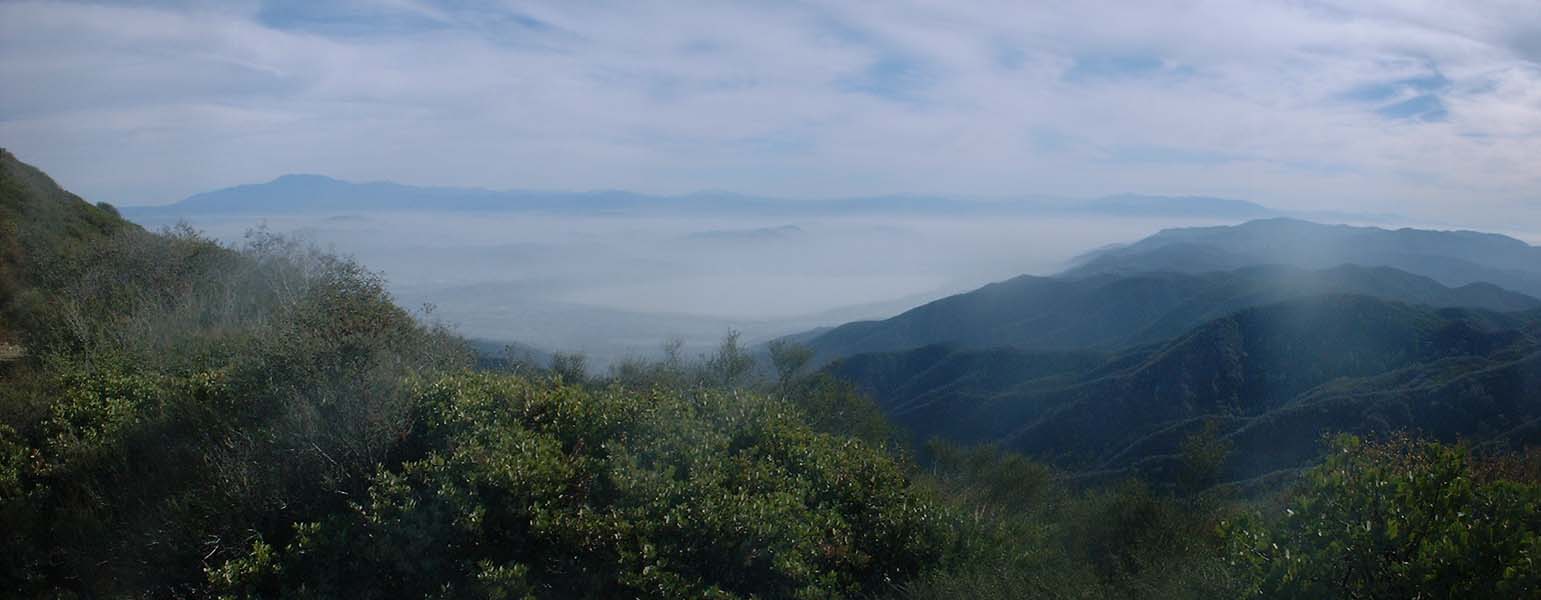
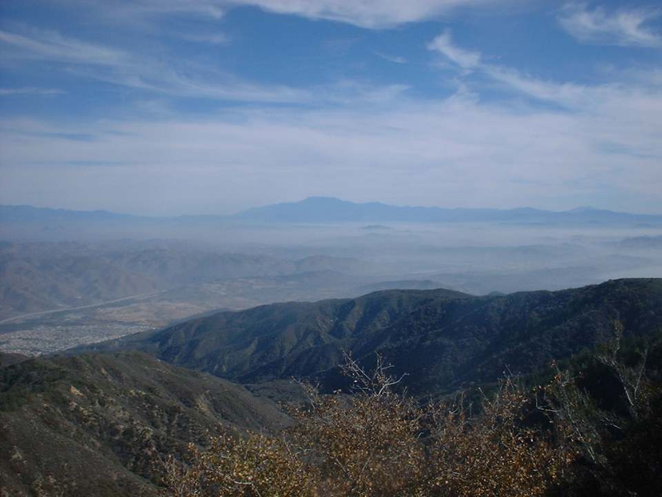
This route starts off with you heading up Trabuco Canyon which after 5.5 miles of taxing sometimes technical climbing you get up to the Main Divide Truck Trail. From here you will hang a left on Main Divide. You will also notice that there is another trail the goes straight up a hill to the right. This is the upper end of the Los Pinos Trail. That trail ends of up at the lower trailhead for the San Juan Trail. It is on my to do list of trails to check out. Anyway after hanging a left of Main Divide you get your first taste of downhill since you started up Trabuco and boy is it fun to have some speed on your wheels even if you are on a fire road. The downhill is short lived as Main Divide does a lot of roller coastering. At around 7.0 miles the views to the East really open up and scenery is absolutely incredible as you look down on Lake Elsinore to the east and the San Bernardino Mountains in the distance to the northeast.
At around 7.37 miles you will pass by East Horsethief Trail that heads down the mountain to the east. You do not want to go this way on this trip. You continue riding along the ridge tops as the and views on either side continue to remain spectacular. At around the 8.0 mile mark you will pass the upper trailhead of the West Horsethief Trail. If you need to cut this route short, this is the place to do it. I have not ridden this trail but meets up the Trabuco Trail that you came up on.

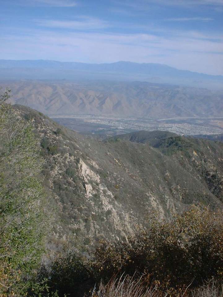
Here is another stunning view looking east from Main Divide. I believe this photo was taken around the 9 mile mark just before a steep section of climbing up to the highest point on this route as you head up Trabuco Peak.

Once you get past Trabuco Peak you get a break from climbing and as Main Divide losses some elevation. At 11.3 miles your com to the junction of Indian Truck Trail. It bears off the right and down. You will stay to the left and go uphill.

When you get to this point at around 12.5 miles for about a mile and a quarter. The grade however is no where near as tough as some of the other climbs on Main Divide. you know you are getting close to the upper end of the Holy Jim Trail. The trail head is just off the left hand side of the picture. It is marked with a round metal post (about 4" in diameter) that it painted brown and yellow. The post is off to the left hand side of the truck trail. In this picture you can see where Main Divide continues on to Santiago Peak (very top of the ridge). You can also see a single track trail in the middle of the picture that has a bunch of switchback in it. It appears that the trail starts at the upper part of main divide and joins back up with at lower portion of Main Divide at the bottom of the picture. I have more exploring to do. Anyone with some firsthand knowledge of this section please email me with the goods. After rolling down the this section in the picture you will be a the Holy Jim upper trailhead at mile 13.10. From here you get to enjoy the wonderful Holy Jim Trail in the downhill direction. Please see my Holy Jim Trail page for the detail on this trail.
Additional Information

Here
is a aerial photograph of of the upper end of the Holy Jim trail.
There is a trail in blue that switchbacks down the side of the hill is called
Upper Holy Jim. The bottom of it comes out right by the Holy Jim
trail where Main Divide makes a sharp turn about 50 yards from the Holy Jim
trailhead. I have heard that the moto types play on it quite a bit but it
is rideable on a mountain bike. On the map in green is where the Coldwater
trail heads off down the east side of the Santa Ana Mountains. I have not done
Coldwater but I hear it is a fun singletrack that has some loose and steep
sections. There is a loop ride on my to do list that goes up the Indian
Truck Trail on the east side of the Santa Anas to Main Divide, then up past Holy
Jim to the spot of the photo where upper Holy Jim and Coldwater start off at.
(BTW the ride up Main Divide from Holy Jim to that spot is a real bruiser)
That area at the top where Main Divide switches back, and the two trails head
downhill is a really wide area where the 4x4 types go and try to get up the side
of the hill by cutting off the switchback. It is pretty torn
up.
Humping it up Main Divide from Holy Jim and then taking Upper
Holy Jim back down to Holy Jim could be a nice add-on loop before heading down
Holy Jim. (Do you think I said Jim enough times in that
sentence?)